Landscape Planning Studio

HUMAN ENVIRONMENT
WHAT'S BEING SAID?
إن امطرت، العيون سترفض النزول
محمّد المالكي-
“Eyes will refuse to look away when it rains”
- Mohammed al-Malki
جبل إبراهيم معلم سياحي بأثارة وطبيعته الحالمة
جريدة الرياض-
“Jabal Ibrahim is a tourist attraction with its dreamy nature and cultural heritage”
- Al-Riyadh Newspaper
كل ما خلق ربّي موجود في هالجبل الّا الأسد
شقران المالكي-
“All of God’s creatures exist on this mountain, except for lions”
- Shaqran Al-Malki
من الأماكن القليلة المتبقية لمواطن النمر العربي بالمملكة
جريدة الرياض-
One of the few remaining habitats of the Arabian Leopard
- Al-Riyadh Newspaper
جبل إبراهيم جمال يعانق السماء ينتظر من يفك
رموزه وأسراره
جريدة الوئام-
Jabal Ibrahim embraces the sky waiting for someone to discover its mysteries and unravel its secrets
- Al-Wiam Newspaper
جنة الله في أرضه
Heaven on Earth
- ADSLGate
نحن في معاناة لا يعلمها الّا الله من حقّين الصيد
محمّد المالكي-
We are in a struggle with hunters that only Allah knows of
- Mohammed al-Malki
واحدة من أغنى المناطق في السعوديّة
م. عثمان لولن-
One of the richest landscapes in the Kingdom
- Landscape Planner Othman Aishah
سماء زرقاء صافية، صخور بيضاء عالية ، أرض خضراء زاهية
الشاعر غبدالله المالكي-
Clear blue skies, high white rocks, bright green land
- Malki Poet
والله ودّنا تسير محميّة
ونعطيهم دراهم
محمّد المالكي-
We would pay money for it to become protected
- Mohammed al-Malki
THE PEOPLE
The proposed reserve lies mainly within the Governate of Makkah and Bani Malik tribal lands, except for the areas east of Wadi Turubah which are in Al-Baha region and Bilad Zahran. The pastures of the wadi floor itself however are used by several tribes.

بلاد بني مالك
Bani Malik
54% of study area
390.87 sq. km
9,421 Dwellers
Total Study Area
723.84 sq. km
17,516 Dwellers
بلاد بني زهران
Bilad
Zahran
46% of study area
332.97 sq. km
8,095 Dwellers
BJILAH
Bjilah is the daughter of Saab bin Ali bin Saad Bin Al-Asheera, a tribe known by the name of its grandfather: Saad bin Muhaj bin Adad bin Zaid bin Yashjab bin Areeb bin Zaid bin Kahlan bin Saba bin Jishab bin Yahab bin Qahtan. He was known as Saad Al-Asheera "The Clan", because his life lasted until his sons and grandchildren became 300 men. When they ride together, he would be asked about his many entourage, so he answers: "They are my tribe" in fear of envy.
Ibn al-Atheer said in his book "Manal al-Taleb" that Omar ibn al-Khattab (may Allah be pleased with him) asked Amr ibn Ma'ad Yakrib, who was the swordsman of Saad ibn Abi Waqqas (may Allah be pleased with him) after the opening of Qadisiyah, about the tribes of the army. So he asked "What do you think about Illa bin Jald?" Amr said: "أولئك فوارس أعراضنا ، و شفاء أمراضنا، و أقلنا هربا" "What about Saad al-Asheera?" asked Omar, so he said: "أعظمنا خميسا، وأكبرنا رئيسا، وأشدنا شريسّا" .They brought together the multitude, the leadership, and the intensity.
 Young Malki Man |  Bani Malik in Tihama |  Bani Malik in Tihama |  Bani Malik Thatched Houses in Tihama |  Bani Malik in Suq as-Sabt |
|---|

Bjilah Bani Malik
THE PEOPLE & INFRASTRUCTURE
The area is fertile enough to have been settled for so long: a large ancient cemetary, for example, marks the site of Suk ar-Radiyah at the mouth of Wadi Kindha, just east of the Wadi Aradah Farmland, where the villagers and bedu traditionally met to exchange products. The present population in villages and camps surrounding Jabal Batharah and Wadi Turubah could be less than 10,000, supplemented by many hundreds of expatriate workers: Egptian farm laborers, Sudani and Chaddian herders, Pakistani builders and Indian and Bangladeshi shop assistants. Our study area's main market and center is Al-Qari', a Wadi 'Aradah village moved to an inconveniently restricted site next to the amirate on the completion of the highway some 30 years ago.
EXPATRIATE WORKERS' NATIONALITIES


HERDERS
SHOP
ASSISTANTS
FARMERS
HERDERS
BUILDERS
SHOP
ASSISTANTS
SCHOOLS

Jabal Batharah's district's provision of schools is necessary, although local girls do not go to school. The villages of Jabal Batharah have once had one secondary school for boys, but due to the intensive urbanization in the last 50 years, the amount of students has dropped down to only 3 kids, which is enough for the Ministry of Education to shut down the school. Economically, socially, and politically speaking, it is difficult to bear being uneducated, and that is why the latest generation of parents insist on educating their boys, which is also the ultimate reason the younger families and tribes have immigrated from their villages. The use of foreign labor, the ease of travel, the better opportunities for education and jobs with the government available in the towns have now drawn most of the young men to work elsewhere.

GENERAL SERVICES

The lack of good roads and of other services such as telephone and electricity (privately and expensively supplied) is strongly felt by the local people when they compare it with the relative wealth of their near neighbors in Al-Baha. Many new houses are occupied only during the 2-3 months of the summer holidays.
DISEASES

Hospital staff said the main illnesses among Saudis were diabetes and conditions related to stress and the lack of exercise. Among expatriates, bronchial troubles exist. Malaria is no longer the scourge it was 50 years ago. Bilharzia was reported from Wadi Kid, but two recent cases may well have been imported by Egyptian laborers, but the local youth were not discouraged from bathing in Wadi Turubah, and no cases were reported from swimming in it.
Bronchial Diseases

Exist among expatriates
Malaria

No longer
exists
RESOURCE USE
Bilharzia

Cases reported
from Wadi Kid
&
2 Cases reported about Egyptian laborers
"We abuse land because we regard it as a commodity belonging to us. When we see land as a community to which we belong, we may begin to use it with love and respect. "
– Aldo Leopold
Zimmerman referred to elements of the environment that do not have human utility as ‘neutral stuff’ and not resources. Resources, therefore, are dynamic both in space and time and very much related to the perception of their worth to a particular person or society.

1. FARMING
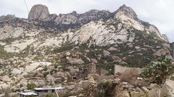
The prosperity of the area depends largely on rainfed terraces behind the escarpment in the wide valleys of Wadi Mahwah, Wadi As-Sayilah and Wadi Aradah shown in the video earlier. Most of these terraces are ancient. Who exactly built the large ones, and how is a mystery, some people even claim that ghosts have helped in building them.
The principal crops are vegetables such as tomatoes, lettuce, cucumbers, okra and onions, produced for the markets of Al-Qari', Taif and Makkah by expatriate laborers, and fruits, which are usually the responsibility of the Saudi landowners themselves. These include almonds (a specialty of the mountain), pomegranates which are widely planted, grapes, apricots, peaches, plums, and mandarins.

PRODUCTS

FRUITS
VEGETABLES
Mandarin
Pomegranate
Almond
Peach
Grapes
Apricots
Cucumber
Onion
Okra
Lettuce
Tomatoes
Mountains
Aquifers
Wells
Rainfed Terraces
Distributed to
Al-Qarei, Al-Taif,
& Makkah
But with the out-migration of local people, many farms have become of less importance to their owners. Many fields, especially the hill terraces, are now unused and are falling back into the hillsides or becoming the source of erosion gullies. It might still be possible to save these by afforestation. The principal complaint of these farmers is the poor quality of the tracks, especially in the flood-prone wadi beds such as Wadi Aradah, which makes it much harder for them to market their products in good condition. The average annual income for farmers is reported to be S.R. 30,000-60,000 S.R. 50,000 for government officials, and 3,600-6,000 for laborers.
 |  |  |  |  |
|---|---|---|---|---|
 |  |

2. HUSBANDRY
The second main land-use is stock rearing, mostly in the sub-humid to semi-arid country which is watered by streams well behind the escarpment. Grazing exists near the scarp but is secondary to farming there. However, on good grass alongside water as in Wadi Aradah and Wadi Turubah, the pressure of grazing is very heavy. In May 1997, a team from the SWA saw a cluster of flocks in lower Wadi Turubah az-Zahran numbering between 400-500 sheep, and the two permanent camps at Al-Aghwar, the head of the stream in Wadi Aradah claimed to be pasturing 1,000 animals. Poor shepherd families have at least 50 sheep, and the rich ones have up to 800.
Poor Families
Rich Families


At least
50 sheep

Up to
800 sheep
It is a long established practice for farmers from the highlands to pasture their cows for a year or more in these well-watered valleys. Many small groups of cattle were seen as well as goats, camels. and a few feral donkeys, all contributing to the drastic overgrazing of the wadis which extends up their sides 150-250 meters. Any side valley accessible from Wadi Turubah is used, though less grazed.
18 semi-permanent shepherd camps which move from place to place within the valley, were counted in the 35 km of wadi between the last farmland in Wadi Aradah and the irrigated fields of Wadi Isharah, plus six in the lowest 8 km of Wadi Turubah az-Zahran and two in Wadi Kid. If an average flock size of 250 per camp is assumed, the numbers based on these semi-permanent camps alone could total from 6,000-7,000 herbivores. These camps seem semi-permanent and so may no longer allow the wadi to recover from seasonal grazing. The vegetation of lower hillsides has been altered by this overgrazing, though, the upper hillsides, too far from water for easy access by sheep, are less affected, especially where they are bouldery.


GRAZERS

Semi-Permanent
Shepherd Camps

=
Herbivores
Herbivores
in Total
 |  |  |  |  |
|---|---|---|---|---|
 |

3. HIMAH
The belt of land on the sub-humid edge of the arid country is where the largest number of himas used to exist: not so wet that droughts are not a problem, nor so dry that a good grass crop cannot be grown in case of drought. Since himas were abolished by the Ministry of Justice some 40 years ago these can no longer be defended against intrusion, although several are claimed to still be functioning. At the head of Wadi Mahwah, a murder occurred some 30 years back as a result of this change in customary practice.
In the study area Bani Malik are divided into: Bani Hashir (of Aba Al-Mar) dwell on the northern part of Jabal Batharah from Al-Hajrah to upper Wadi Kid, while Bani Makhshi (of Bani Mohammad) stay on the southern part of the mountain. Except for the lands east of Wadi Turabah that are within Al-Bahah Imarah which are used by the Zahran, it is also Bani Malik's lands. The pastures of the wadi floor are used by several tribes.


Himah Bani Makhshi
HONEY EXTRACTION
PRICE
RANGE
Himas were used mostly for the provision of grass for draft animals, and only camels of which there were few, were allowed to graze there. Cutting was done by hands of woman only, and it was then considered shameful for men to enter the hima.
In this belt on the edge of the sub-humid zone, sheltered from the climate of the scarp edge but still humid, the team also saw the most honey hives and honey-lorries, each carrying 35 or so mobile hoves, enabling the bees to follow the seasonal flowers. These were in Wadi Aradah and Wadi Turubah az-Zahran where there are large groves of Acacia and Zizyphus, both source of winter honey. The hillsides to the west are well vegetated with Lavandula dentata, the source of the best white summer honey, which comes from otostegia, pulicaria, and pavetta as well. The dominant sub-shrub psiadia gives a reddish honey in spring while it is held to be of medicinal value. This is a local resource which should be encouraged and conserved. The price of S.R. 600-1,000 per kilo is competitive with prices near Taif.


REDDISH
HONEY
WHITE SUMMER
HONEY
WINTER
HONEY


=

Acacia
+
Zizyphus
Lavendula dentata
+
Otostegia
+
Pulicaria
+
Pavetta
Psiadia
600-1,000 S.R.

ANTIQUE FORTS
The novels say that there was a misunderstanding between the tribes of Bani Makhshi of the sons of Malik and the tribes of Zahran, where the Zahran tribes were equipped to invade Bani Malik.
There was a Malki woman married to a man from Zahran, and as soon as she heard the news of the invasion, in the next morning, she went and informed Bani Malik that the date of the invasion will be within a few weeks, giving them time to prepare. The tribes of Bani Makhshi and Bani Hashir of Bani Malik equipped themselves for the battle, quickly set a tight line of forts built with monzogranite and basalt surrounding the highest mountains, and opened a route for Bani-Zahran to rendezvous into the center. The plan worked and they have been invaded by almost 1,000 men, all killed in the center of a circle of forts as they had no way to go back. This battle is infamous by the name of Al-Najilah النجيلة, as the blood was similar to Al-Nujool النجول, which is the water that runs off the mountains.
:يقول ابن شطحان
مع زهران شبّينا الشبوب
وعانينا المشاكل والحروب
وهم ونعم كما نار اللّهوب حربناهم وهم روزة ثقيلة
 |  |  |  |  |
|---|
URBAN GROWTH PATTERN
Widd, with no families remaining to crop and graze the fields, it is accessible only by mountain camel and is over an hour's walk uphill. Its buildings are becoming ruinous and its irrigated fruit trees have died but it remains an arcadian retreat hard to imagine existing in Saudi Arabia.
THE MOUNTAIN TRAIL: ADHIR TO WIDD
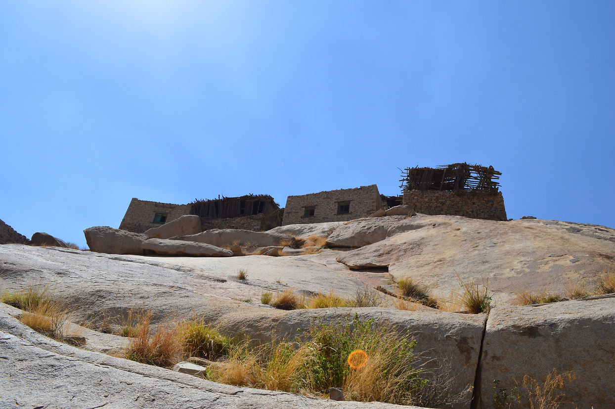
The most attractive expedition on the mountain is reached via the rough track to the hamlet of Adhir where the cars' limit is reached. From there the path climbs up 120 meters of bouldery hillside in 1.5 kilometers to meadows and on to the nearby abandoned village of Widd. This is still a functioning camel trail, with steep though manageable steps, bordered by lavender, up the rocky densely vegetated slope, which needs no construction.
At the top of an hours' climb the path emerges onto a wide expanse of mewadows surrounded by the peaks of the mountain. A beautiful old stone house belonging to villagers from Adhir still remains. The antique village of Widd is 100 meters and half an hour's walk higher up on quite a steep rocky ridge in the center of the basin.
At the top of an hours' climb the path emerges onto a wide expanse of meadows surrounded by the peaks and pinnacles of the mountain. A beautiful old stone house belonging to villagers from Adhir still remains. The antique village of Widd is 100 meters and half an hour's walk higher up on quite a steep rocky ridge in the center of the basin.
At this point, Widd can be seen from far. In order to get to it, one has to pass through the village's abandoned meadows which have been invaded by thorny weeds which could give the visitor a hard time. On the other hand, multiple of houses under rocks can be found and visited while on the way to Widd.


WIDD VILLAGE
MOUNTAIL TRAIL

1ST EXPERIENCE
HOUSES UNDER ROCKS
From there the path climbs up 120 meters of bouldery hillside in 1.5 kilometers to meadows and on to the nearby abandoned village of Widd. This is still a functioning camel trail, with steep though manageable steps, bordered by lavender, up the rocky densely vegetated slope, which needs no construction.

2ND EXPERIENCE
MOUNTAIN TRAIL

3RD EXPERIENCE
PINNACLES

4TH EXPERIENCE
MEADOW TRAILS
4TH EXPERIENCE
WIDD VILLAGE
The final experience is being actually present in such an antique village. What we consider a trip to Widd, was an everyday routine to its dwellers, and its difficult accessibility is the main reason it is now abandoned. The abandoned village is composed of 20 houses and a masjid.