Landscape Planning Studio
LOCATION
Our study area lies on the escarpment in the southernmost series of mountains of the Hijaz at Lat. 20° 28'N & Long. 41° 13'E , 120 kilometers southeast of Al-Taif and 50 kilometers directly north-northwest of Al-Bahah. The study area has been compared with these two cities as they are the nearest cities with a population over 100,000.
Total Study Area
723.84 sq. km
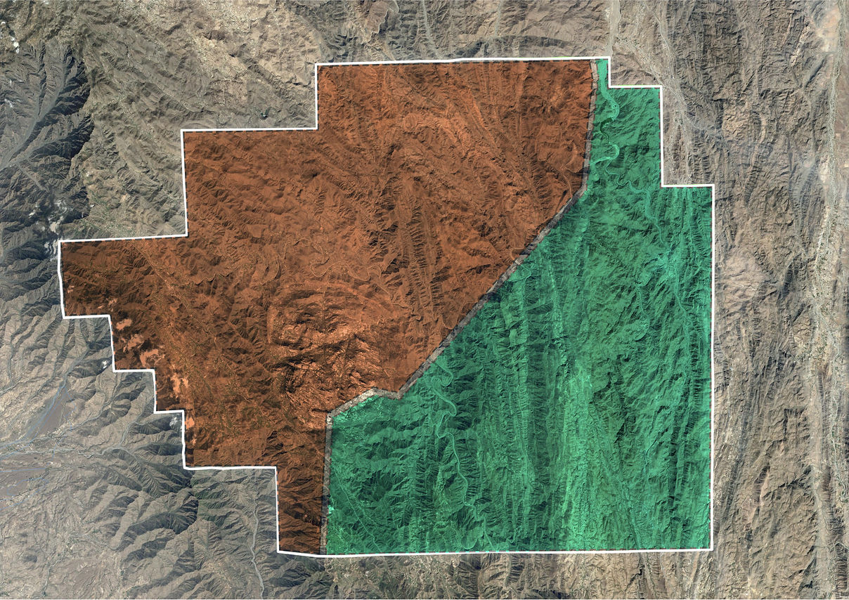
منطقة مكّة
Makkah Region
54% of study area
390.87 sq. km
منطقة الباحة
Al-Bahah Region
46% of study area
332.97 sq. km
PROVINCIAL SCALE
Our study area can be divided into three different provinces, one in the Makkah Region being Maysan entirely, and two in Al-Bahah being Al-Mandaq and Al-Qara.
The part of Maysan included in our study area belongs to Bani Malik: Bani Hashir on the northern part of Jabal Batharah from AlHajrah to upper Wadi Kid, Bani Makhshi on the southern part of the mountain.
Bani Malik tribal groups have existed in Wadi Turabah, except for the lands east of Wadi Turabah that are within Al-Bahah Imarah, which are used by Al-Zahran. The pastures of the wadi floor are used by several tribes.
Al-Mandaq
Total Population: 27,235
Approximate Population in Study Area: 3,635
Al-Qara
Total Population: 31,480
Approximate Population in Study Area: 4,460

محافظة ميسان
Maysan Province
390.87 sq. km
محافظة المندق
Al-Mandaq
Province
96.77 sq. km
محافظة القرى
Al-Qara Province
236.2 sq. km
 Al-MandaqDisplayed in the photo is the outstanding homogeneity of Juniper trees in Al-Mandaq province, a constant hub for the production of honey. |  Al-QaraWhen seen from satellite images, Al-Qara's mountains might be deceiving, as it appears to be dense in trees when this photo summarizes the true nature of its landscape. |  MaysanA distant view from the northwestern corner of the study area where Jabal Batharah is displayed in the background. |
|---|
ADMINISTRATIVE CENTERS
In the Kingdom, provinces are divided into administrative centers, which are also divided into administrative centers of Category A and Category A, as Category A centers have a higher potential of being declared a province.
In our study area, Haddad Bani Malek (Category A) is the least included yet the most populated, while Abu Rakah (Category B) is twice more included yet carries the least population. Although they are neighboring centers in Maysan, due to geological reasons, Abu Rakah's harsh mountainous landscape has supported the least amount of tribal villages and settlers.
Haddad Bani Malek
Total population: 12,850
Approximate population in study area: 2,389
Abu Rakah
Total population: 6,825
Approximate population in study area: 462
Al-Qarei'
Total population: 10,000
Approximate population in study area: 6,570
Total approximate population in the Makkah Region: 9,421
Total approximate population in Al-Bahah region: 8,095
Total approximate population in study area: 17,516

مركز حدّاد بني مالك الإداري فءة ا
Haddad Bani Malik
مركز القريع بني مالك الإداري
فئة ب
Al-Qarei' Bani Malik
مركز أبو راكة الإداري
فئة ب
Abu Rakah
مركز نخال الإداري
Nikhal
مركز برحرح الإداري
Barahrah
مركز بني عدوان وبني حرير الإداري
Bani Idwan & Bani Hareer
METHODOLOGY
"We need, today, an understanding of natural processes and its expression and, even more, an understanding of the morphology of man-nature, which, less deterministic, still has its own morphology, the expression of man-nature as process."
B1-Natural and Cultural Resources Inventoried and Mapped
A
C
TOTAL STUDY AREA
ECONOMIC INVENTORY
B2a-Inventoried Data Interpreted
B2b-Intrinsic Suitability Maps Produced
B3a-Intrinsic Resources Rating System Established
B3c-Data Synthesized into Combined Suitability Map
B3b-Compatible and Incompatible Used Grouped
NATIONAL PARK ZONING
D
VISIBILITY CRITERIA ESTABLISHED
E
FORM AND DESIGN CRITERIA ESTABLISHED
F
IMPLEMENTATION POWERS ACQUIRED